News Archive

April 8, 2024: Coastal Flood Advisory In Effect Until 1:00 AM Tuesday

April 8, 2024 – From the National Weather Service

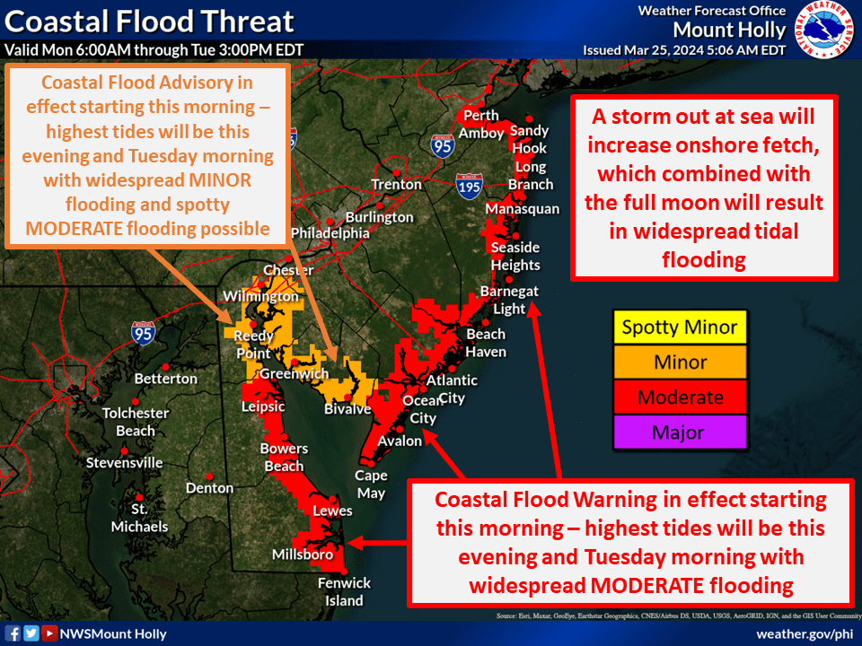
COASTAL FLOOD ADVISORY REMAINS IN EFFECT UNTIL 1:00 AM TUESDAY

WHAT…Up to one foot of inundation above ground level in low-lying areas near shorelines and tidal waterways.

WHERE…Cumberland, Atlantic, Cape May, Atlantic Coastal Cape May, Coastal Atlantic and Southeastern Burlington Counties

WHEN…Until 1 AM EDT Tuesday.

IMPACTS…At this level, flooding begins on the most vulnerable roads in coastal and bayside communities, and along inland tidal waterways. Some partial or full road closures are possible.

ADDITIONAL DETAILS…The most widespread minor tidal flooding is expected with the evening high tide cycle today.


PRECAUTIONARY/PREPAREDNESS ACTIONS… If travel is required, allow extra time as some roads may be closed. Do not drive around barricades or through water of unknown depth. Take the necessary actions to protect flood-prone property.

April 8, 2024: Coastal Flood Advisory In Effect Until 1:00 AM Tuesday2024-04-12T09:49:43-04:00

Hazardous Weather Alert: Coastal Flood Threat, March 25, 2024

March 25, 2024 – A message from the Cape May County Emergency Management Communications Center

COASTAL FLOOD THREAT, MARCH 25, 2024: The highest tide levels look likely to occur during this evening’s high tide, while some spots could see tides matching that or even a tad higher on Tuesday morning. Tide levels are expected to start subsiding faster after Tuesday morning’s high tide, but there may still be widespread minor flooding Tuesday evening.

Very high (90 -100%) confidence in the region seeing widespread tidal flooding. High (80%) confidence in widespread moderate flooding.

Hazardous Weather Alert: Coastal Flood Threat, March 25, 20242024-03-29T19:00:18-04:00

February 12-14, 2024 Winter Storm Weather Briefing

February 12, 2024 – A message from the Cape May County Emergency Management Communications Center

Below please find the link to the updated briefing package regarding the winter storm that is forecast to impact the region Tonight into Tuesday.

Moderate coastal flooding is forecast with Tuesday’s high tide, along the New Jersey shore and back-bays. Sussex County (DE) is now forecast to experience moderate coastal flooding as well. Additionally, widespread minor coastal flooding is forecast to occur with the highs tides from today through Tuesday night along all tidal areas of Atlantic coastal NJ & DE, DE Bay, and the tidal DE River.

opens in a new windowClick here for complete briefing package.

February 12-14, 2024 Winter Storm Weather Briefing2024-02-23T14:33:19-05:00

Coastal Flood Warning In Effect February 12-14, 2024

February 12, 2024 – From the National Weather Service

COASTAL FLOOD WARNING REMAINS IN EFFECT FROM 8 AM THIS MORNING TO 3 AM EST WEDNESDAY

* WHAT…One to two feet of inundation above ground level expected in low-lying areas near shorelines and tidal waterways.

* WHERE…Atlantic, Cape May, Atlantic Coastal Cape May and Coastal Atlantic.

* WHEN…From 8 AM this morning to 3 AM EST Wednesday.

* IMPACTS…At this level, widespread roadway flooding occurs in coastal and bayside communities and along inland tidal waterways. Many roads become impassable. Some damage to vulnerable structures may begin to occur.

* ADDITIONAL DETAILS…Minor coastal flooding will occur around the times of the high tides from Monday through Tuesday night. The greatest impacts are forecast to occur with the Tuesday daytime high tide, when moderate coastal flooding is forecast as a strong coastal storm moves offshore.

PRECAUTIONARY/PREPAREDNESS ACTIONS… Take the necessary actions to protect flood-prone property. If travel is required, do not drive around barricades or through water of unknown depth.

Coastal Flood Warning In Effect February 12-14, 20242024-02-15T09:20:22-05:00

Ocean Drive (CR619) Bridge Closure and Detour February 13-14, 2024

February 8, 2024

A message from the office of the Cape May County Engineer.

Notice of Great Channel Bridge closure and detour of Ocean Drive (CR 619)

The Ocean Drive Bridge over Great Channel, which connects Middle Township to the south end of Stone Harbor, will be closed due to construction in order to complete final planned repairs to the bascule span. During active construction hours on Tuesday and Wednesday February 13th and 14th, those motorists wishing to use Ocean Drive (Cr 619) and cross over the bridge will be detoured around the work zone, as this section of Ocean Drive will be closed to through traffic. The bridge and roadway are being closed in order to provide access to install masonry bearing plates under the west bascule girder. The repair work is expected to be completed by February 15, 2024, at which time normal traffic patterns will resume.

Motorists wishing to travel north on Ocean Drive and access the south end of Stone Harbor will be detoured west onto US Route 147 to the Route 9 intersection.  They will then be directed north along Route 9 to Stone Harbor Boulevard (CR 657) where they will be directed east along Stone Harbor Boulevard back to Third Avenue (CR 619).

Motorists travelling south on Third Avenue (CR 619) and wishing to continue heading south to US Route 147 will be directed west at the 96th Street intersection onto Stone Harbor Boulevard (CR 657). Motorist will travel west on Stone Harbor Boulevard to the Route 9 intersection.  Motorists will then be directed south on Route 9 to the intersection of Indian Trail Road (CR 618) where they will be directed east onto US Route 147.

Local Traffic will be permitted approaching the Great Channel Bridge, however, no traffic will be permitted to cross the bridge during the periods of active construction.


Ocean Drive (CR619) Bridge Closure and Detour February 13-14, 20242024-02-23T15:04:49-05:00

January 19, 2024: Winter Weather Advisory In Effect Until 10 PM

January 19, 2024

A Message From the National Weather Service:

WINTER WEATHER ADVISORY REMAINS IN EFFECT UNTIL 10 PM EST THIS EVENING

* WHAT…Snow expected. Some rain may mix in this morning. Total snow accumulations of 2 to 4 inches. Winds gusting as high as 35 mph.

* WHERE…Atlantic Coastal Cape May, Coastal Atlantic and Coastal Ocean.

* WHEN…Until 10 PM EST this evening.

* IMPACTS…Plan on slippery road conditions. The hazardous conditions could impact the morning or evening commute.

* ADDITIONAL DETAILS…Temperatures will rapidly drop into the teens late Friday night. Any untreated roads will become icy and dangerous. Areas of blowing snow are possible over the weekend.

PRECAUTIONARY/PREPAREDNESS ACTIONS… Slow down and use caution while traveling.


January 19, 2024: Winter Weather Advisory In Effect Until 10 PM2024-01-22T13:17:20-05:00

96th Street Water Main Replacement to Commence in February; Includes Monday – Friday Weekly Road Closure

January 18, 2024

Starting in February, construction will commence on the installation of a water main and services along the 200 block of 96th Street, spanning from Second Avenue to Third Avenue. The anticipated start date for the project is the first week of February, with an estimated duration of four weeks.

During the construction period, the roadway will be fully closed from Monday through Friday, specifically between the hours of 7:00 am and 3:30 pm. However, to minimize disruptions, the eastbound lane will be accessible during non-working hours. Additionally, the roadway is set to reopen for weekends, starting from Friday after the completion of work and continuing until Monday morning.

Sidewalks will remain open throughout the construction process.

We appreciate your understanding and patience as we undertake these essential improvements.

96th Street Water Main Replacement to Commence in February; Includes Monday – Friday Weekly Road Closure2024-03-13T10:25:50-04:00
Go to Top