News Archive

Stone Harbor Bird Sanctuary to Close Temporarily for Pesticide Spraying (October 9 and 11, 2023)

October 6, 2023

Stone Harbor Bird Sanctuary to Close Temporarily for Pesticide Spraying

STONE HARBOR, NJ – The Stone Harbor Bird Sanctuary will be closed to the public on October 9, 2023 and October 11, 2023 while wetland restoration experts contracted by the Borough apply aquatic pesticides to control invasive vegetation in the wetlands and transition areas of the sanctuary. Vegetation management will involve the application of the herbicide Habitat®. This application will enable the restoration of native vegetation and wildlife habitat that have been crowded out by non-native, invasive plants, namely common reed (Phragmites australis) and purple loosestrife (Lythrum salicaria).

Habitat® herbicide contains the active ingredient imazapyr and is considered to be a low-volume herbicide (effective at very low rates), which results in a lesser chemical load on the environment. Additionally, it is free of heavy metals, organochlorides and phosphates. With the exception of green plants, Habitat® herbicide is considered to be practically nontoxic as determined by results from EPA-required testing. Results from this testing indicate that it is not a mutagen, carcinogen, terratogen or endocrine disruptor. Furthermore when used as labeled, it should not have a direct adverse effect on mammals, birds, fish, crustaceans, mollusks or insects.

The herbicide will be applied utilizing backpack sprayers and hand wiping equipment, depending on the area being treated.

This project requires the closure of the Bird Sanctuary during the herbicide application. There will be a six (6) hour entry restriction into herbicide sprayed areas. Signage will be posted at each of the four trail heads into the sanctuary during the closure period.

The Borough of Stone Harbor has contracted Princeton Hydro, LLC for the management of the wetland restoration project. For additional information please contact Tyler, Aquatic Operations Manager, Princeton Hydro, LLC, 908-237-5660.

opens in a new windowClick here for Habitat Safety Data Sheet

Stone Harbor Bird Sanctuary to Close Temporarily for Pesticide Spraying (October 9 and 11, 2023)2023-10-19T12:12:39-04:00

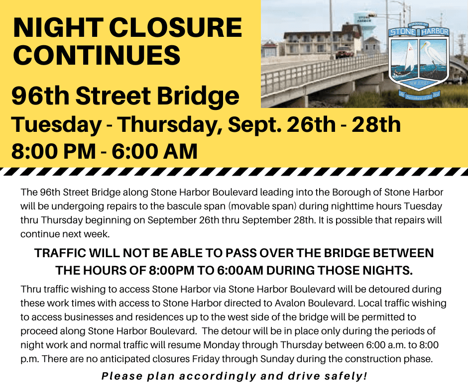
Emergency Repairs to 96th Street Bridge Completed

September 29, 2023

The emergency work at the 96th Street bridge has been completed and there will be no further roadway detours next week.

Emergency Repairs to 96th Street Bridge Completed2023-10-11T13:14:40-04:00

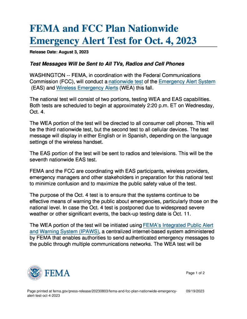
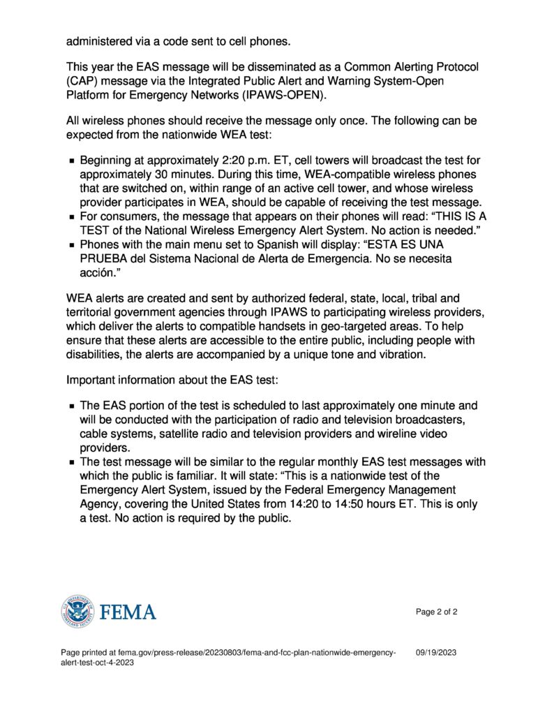
FEMA and FCC Plan Emergency Nationwide Test Alert For October 4, 2023

September 29, 2023 – A message from the Cape May County Emergency Management Communications Center

FEMA and the FCC will be performing a Nationwide Emergency Alert Test on October 4th, 2023 at approx. 2:30pm.
The test will be conducted on all radio, television and cellular providers.

FEMA and FCC Plan Emergency Nationwide Test Alert For October 4, 20232023-10-06T12:17:37-04:00

September 29, 2023 – Coastal Flood Advisory and High Rip Current Risk In Effect through Saturday

September 29, 2023 – From the National Weather Service

COASTAL FLOOD ADVISORY NOW IN EFFECT UNTIL 2 PM SATURDAY
HIGH RIP CURRENT RISK REMAINS IN EFFECT THROUGH SATURDAY EVENING

* WHAT…For the Coastal Flood Advisory, up to one foot of inundation above ground level in low-lying areas near shorelines and tidal waterways. For the High Rip Current Risk, dangerous rip currents.

* WHERE…Eastern Monmouth, Atlantic Coastal Cape May, Coastal Atlantic and Coastal Ocean.

* WHEN…For the Coastal Flood Advisory, until 2 PM EDT Saturday. For the High Rip Current Risk, through Saturday evening.

* IMPACTS…At this level, flooding begins on the most vulnerable roads in coastal and bayside communities, and along inland tidal waterways. Some partial or full road closures are possible. Rip currents can sweep even the best swimmers away from shore into deeper water.

* ADDITIONAL DETAILS…Water levels will remain elevated into the weekend, with minor or near minor tidal flooding possible with the high tides through at least Saturday.

PRECAUTIONARY/PREPAREDNESS ACTIONS…
If travel is required, allow extra time as some roads may be closed. Do not drive around barricades or through water of unknown depth. Take the necessary actions to protect flood-prone property.

Swim near a lifeguard. If caught in a rip current, relax and float. Don`t swim against the current. If able, swim in a direction following the shoreline. If unable to escape, face the shore and call or wave for help.

September 29, 2023 – Coastal Flood Advisory and High Rip Current Risk In Effect through Saturday2023-10-02T09:22:53-04:00

September 28, 2023 – Coastal Flood Advisory In Effect Until Midnight; High Rip Current Risk Through Friday Evening

September 28, 2023

From the National Weather Service:

COASTAL FLOOD ADVISORY IN EFFECT FROM 6 PM THIS EVENING TO MIDNIGHT TONIGHT

HIGH RIP CURRENT RISK NOW IN EFFECT THROUGH FRIDAY EVENING

* WHAT…For the High Rip Current Risk, dangerous rip currents.
For the Coastal Flood Advisory, up to one foot of inundation above ground level expected in low-lying areas near shorelines and tidal waterways.

* WHERE…Eastern Monmouth, Atlantic Coastal Cape May, Coastal Atlantic and Coastal Ocean.

* WHEN…For the High Rip Current Risk, through Friday evening.
For the Coastal Flood Advisory, from 6 PM this evening to midnight EDT tonight.

* IMPACTS…At this level, flooding begins on the most vulnerable roads in coastal and bayside communities, and along inland tidal waterways. Some partial or full road closures are possible.
Rip currents can sweep even the best swimmers away from shore into deeper water.

* ADDITIONAL DETAILS…Water levels will remain elevated into the weekend, with minor or near minor tidal flooding possible with the nighttime high tides on Friday and Saturday.

PRECAUTIONARY/PREPAREDNESS ACTIONS…
If travel is required, allow extra time as some roads may be closed. Do not drive around barricades or through water of unknown depth. Take the necessary actions to protect flood-prone property.

Swim near a lifeguard. If caught in a rip current, relax and float. Don`t swim against the current. If able, swim in a direction following the shoreline. If unable to escape, face the shore and call or wave for help.

September 28, 2023 – Coastal Flood Advisory In Effect Until Midnight; High Rip Current Risk Through Friday Evening2023-09-29T09:40:58-04:00

September 27, 2023 – Coastal Flood Advisory, High Rip Current Risk and High Surf Advisory In Effect

September 27, 2023 – From the National Weather Service
  • COASTAL FLOOD ADVISORY REMAINS IN EFFECT FROM 5 PM THIS AFTERNOON TO 1 AM THURSDAY
  • HIGH RIP CURRENT RISK NOW IN EFFECT THROUGH THURSDAY EVENING
  • HIGH SURF ADVISORY REMAINS IN EFFECT UNTIL 8 PM EDT THIS EVENING
* WHAT…For the High Surf Advisory, large breaking waves of up to 8 feet in the surf zone. For the High Rip Current Risk, dangerous rip currents. For the Coastal Flood Advisory, up to one foot of inundation above ground level expected in low-lying areas near shorelines and tidal waterways.

* WHERE…Atlantic Coastal Cape May and Coastal Atlantic.

* WHEN…For the High Rip Current Risk, through Thursday evening. For the High Surf Advisory, until 8 PM EDT this evening. For the Coastal Flood Advisory, from 5 PM this afternoon to 1 AM EDT Thursday.

* IMPACTS…At this level, flooding begins on the most vulnerable roads in coastal and bayside communities, and along inland tidal waterways. Some partial or full road closures are possible. Dangerous swimming and surfing conditions and localized beach erosion. Rip currents can sweep even the best swimmers away from shore into deeper water.

* ADDITIONAL DETAILS…Water levels will remain elevated through the balance of the week, with minor or near minor tidal flooding possible with the high tides on Thursday evening.

PRECAUTIONARY/PREPAREDNESS ACTIONS…
If travel is required, allow extra time as some roads may be closed. Do not drive around barricades or through water of unknown depth. Take the necessary actions to protect flood-prone property.

Inexperienced swimmers should remain out of the water due to dangerous surf conditions.

Swim near a lifeguard. If caught in a rip current, relax and float. Don`t swim against the current. If able, swim in a direction following the shoreline. If unable to escape, face the shore and call or wave for help.
September 27, 2023 – Coastal Flood Advisory, High Rip Current Risk and High Surf Advisory In Effect2023-09-28T09:14:49-04:00

September 26, 2023 – Higher Than Normal Tides Expected, Coastal Flood Warning In Effect

September 26, 2023
HIGHER THAN NORMAL TIDES EXPECTED – COASTAL FLOOD WARNING IN EFFECT

One to two feet of inundation above ground level is expected in low-lying areas near shorelines and tidal waterways.

The persistent Northeast winds, forecasted to continue over the next few days, are preventing bay levels from returning to their usual norms. Adding to the concern, a New Moon is slated for Friday, which sets the stage for a series of potentially impactful flooding events, commencing with tonight’s high tide at 6:45 PM.

Residents are advised to be aware that moderate flooding is expected, as the second high tide of each day through Saturday is anticipated to exceed normal levels.
Specifically, residents residing west of Third Avenue, are strongly encouraged to relocate their vehicles to higher ground, starting from Second Avenue and eastward.
September 26, 2023 – Higher Than Normal Tides Expected, Coastal Flood Warning In Effect2023-10-02T09:23:08-04:00
Go to Top