September 20, 2023
𝙈𝙚𝙨𝙨𝙖𝙜𝙚 𝙛𝙧𝙤𝙢 𝙩𝙝𝙚 𝘾𝙖𝙥𝙚 𝙈𝙖𝙮 𝘾𝙤𝙪𝙣𝙩𝙮 𝙀𝙢𝙚𝙧𝙜𝙚𝙣𝙘𝙮 𝙈𝙖𝙣𝙖𝙜𝙚𝙢𝙚𝙣𝙩 𝘾𝙤𝙢𝙢𝙪𝙣𝙞𝙘𝙖𝙩𝙞𝙤𝙣𝙨 𝘾𝙚𝙣𝙩𝙚𝙧:
Here are the key messages for our region regarding the potential impacts of a coastal storm over the weekend.
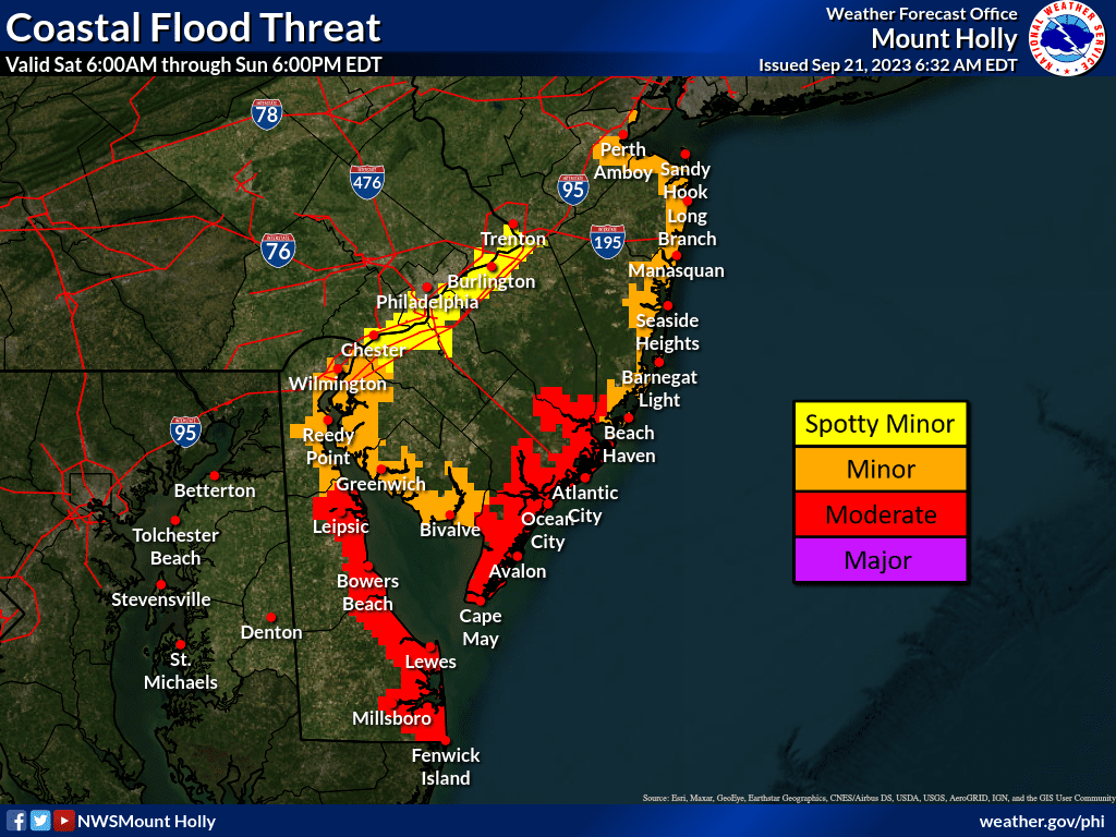
1 – We are still expecting a coastal storm to impact our region this weekend, starting Friday Night and lasting into Sunday. The most significant impacts will be to areas along the immediate coast on Saturday, in the form of coastal flooding and strong winds, along with periods of heavy rain.
2 – While there is still uncertainty regarding exact coastal water levels on Saturday, at this point it appears that most of the New Jersey and Delaware coast will experience at least minor coastal flooding, and some areas, particularly coastal southern New Jersey and southern Delaware, may experience moderate coastal flooding. The greatest concern for coastal flooding will likely occur during the Saturday afternoon high tide, around 2-3pm, but could linger into following high tide cycles on Sunday.
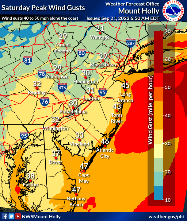
3 – Strong onshore winds are forecast on Saturday. Gusts up to 50 mph are possible across the immediate coastal areas and over the ocean waters; peaking up to 40 mph inland. Combined with coastal flooding, this could result in at least minor beach erosion, along with dangerous rip currents. A Gale Watch is in effect for the waters a Wind Advisory may be necessary for land areas near the coast.
4 – Periods of rain will fall from Friday night into Sunday, possibly heaviest on Saturday. Locally over 2 to 3 inches of rain may fall across portions of the region. That still depends on the track of the storm system, and that track remains uncertain. At this time those heavier rain amounts are forecast for the coastal areas, with less than 2 inches forecast northwest of I-95. Aside from the coastal flooding, some occasional urban and small-stream flooding of low-lying areas could occur during periods of heavier rain.
5 – There is potential that the system acquires some tropical characteristics and become a named storm, but this remains highly uncertain. Regardless of if that happens, the overall impacts for our area listed above will be similar.