January 9, 2024, From the National Weather Service:
opens in a new windowCLICK HERE FOR COMPLETE WEATHER BRIEFING
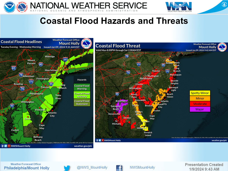
COASTAL FLOOD ADVISORY REMAINS IN EFFECT FROM 5 PM THIS AFTERNOON TO 10 AM WEDNESDAY
WHAT…Up to one foot of inundation above ground level expected in low-lying areas near shorelines and tidal waterways.
WHERE…Atlantic, Cape May, Atlantic Coastal Cape May and Coastal Atlantic.
WHEN…From 5 PM this afternoon to 10 AM EST Wednesday.
IMPACTS…At this level, flooding begins on the most vulnerable roads in coastal and bayside communities, and along inland tidal waterways. Some partial or full road closures are possible.
ADDITIONAL DETAILS…The highest water levels are expected in the back bays.
PRECAUTIONARY/PREPAREDNESS ACTIONS… If travel is required, allow extra time as some roads may be closed. Do not drive around barricades or through water of unknown depth. Take the necessary actions to protect flood-prone property.
HIGH WIND WARNING REMAINS IN EFFECT FROM 6 PM THIS EVENING TO 4 AM WEDNESDAY
WHAT…Southeast to south winds 35 to 45 mph with gusts up to 65 mph expected.
WHERE…Portions of southern Delaware and central and southern New Jersey.
WHEN…From 6 PM this evening to 4 AM EST Wednesday.
IMPACTS…Damaging winds will blow down trees and power lines. Widespread power outages are expected. Travel will be difficult, especially for high profile vehicles.
ADDITIONAL DETAILS…Southeast winds will increase during today and become stronger later this afternoon. The damaging winds are expected to occur this evening, and these could be locally enhanced with a narrow line of intense showers later tonight.
PRECAUTIONARY/PREPAREDNESS ACTIONS… People should avoid being outside around trees. If possible, remain in the lower levels of your home during the windstorm, and avoid windows. Use caution if you must drive.
FLOOD WATCH REMAINS IN EFFECT FROM 1 PM EST THIS AFTERNOON THROUGH WEDNESDAY AFTERNOON
WHAT…Flooding caused by excessive rainfall continues to be possible.
WHERE…Portions of Delaware, including the following areas, Delaware Beaches, Inland Sussex, Kent and New Castle, northeast Maryland, including the following areas, Caroline, Kent MD, Queen Annes and Talbot, New Jersey, including the following areas, Atlantic, Atlantic Coastal Cape May, Camden, Cape May, Coastal Atlantic, Coastal Ocean, Cumberland, Eastern Monmouth, Gloucester, Mercer, Middlesex, Northwestern Burlington, Ocean, Salem, Southeastern Burlington and Western Monmouth, and southeast Pennsylvania, including the following areas, Delaware, Lower Bucks and Philadelphia.
WHEN…From 1 PM EST this afternoon through Wednesday afternoon. * IMPACTS…Excessive runoff may result in flooding of rivers, creeks, streams, and other low-lying and flood-prone locations.
ADDITIONAL DETAILS… – Rainfall of 1 to 3 inches possible later today and tonight, with the heaviest rain falling later this afternoon and this evening. The ground remains very saturated following multiple rounds of heavy rainfall over the last month. A period of higher hourly rainfall rates is possible tonight which would enhance the potential for flooding, particularly in the urban areas. Tidal inundation combined with runoff in coastal areas may significantly elevate the flood risk, especially if occurring during times of high tide. – opens in a new windowhttp://www.weather.gov/safety/flood
PRECAUTIONARY/PREPAREDNESS ACTIONS… You should monitor later forecasts and be alert for possible Flood Warnings. Those living in areas prone to flooding should be prepared to take action should flooding develop.

