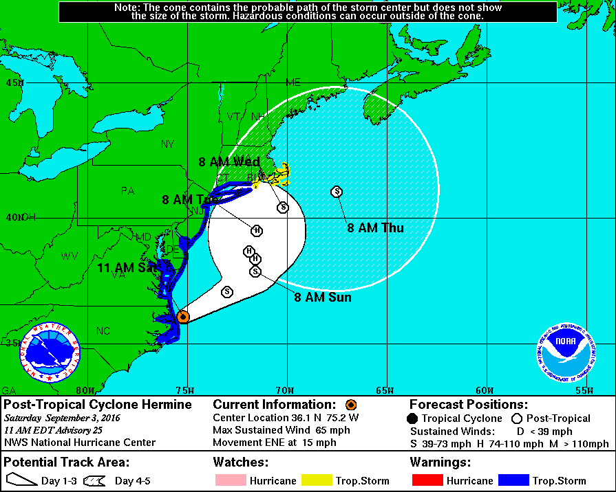
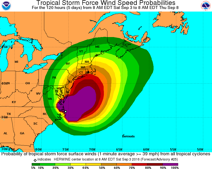
The National Weather Service has continued the Tropical Storm Warning for the Borough of Stone Harbor. Our community will continue to experience impacts from Hermine through the Labor Day weekend which will include rain, strong winds, coastal flooding, rip currents, and rough surf. The Stone Harbor Office of Emergency Management participated in a conference call on Saturday morning with the County and State officials regarding this storm.
The 11:00am advisory from the National Weather Service is tracking the storm slightly further out to sea. However, the potential still exists for moderate to major coastal flooding at time of high tide over the next few days, especially during the Sunday evening and Monday morning high tide events. Residents and visitors must remain aware of the forecast and any potential changes especially over the next 48 hours.
The Stone Harbor Office of Emergency Management is asking visitors to consider leaving the Borough of Stone Harbor during the afternoon and early evening hours on Saturday, September 3rd. High tide on the back bay occurs at 10:48pm on Saturday; high tide on Sunday occurs at 11:14am and again at 11:25pm, and high tide on Monday will be at 11:53am. Moderate to potentially major coastal flooding is expected at times of high tide on Sunday and again on Monday. Flooding conditions may worsen on Sunday and Monday. If the storm remains off of our coast for an extended period of time, it may worsen subsequent high tide events over the next few days.
In advance of any flood advisory, watch, or warning, consider moving your vehicle to higher ground. Never park your vehicle on a bridge or traffic island. Street flooding may also occur during periods of heavy rainfall. Never attempt to drive your vehicle on any flooded street or through a flooded intersection as this puts you in danger and also creates an unnecessary wake that can damage private property and other vehicles. It is best that you shelter at your property during times of high tide; rising tidal flooding typically subsides within a couple of hours of a high tide along the back bay. If you have an emergency during the storm, please dial 911.
Never attempt to drive on any flooded street for any reason at any time. You endanger yourself, compromise your vehicle with salt water, and create a wake that can damage others’ personal property when you drive through flood waters.
Bathers are not permitted to enter the ocean in Stone Harbor until further notice. Boaters are asked to check on their boats, secure them, and if possible, remove them from slips. Secure all property prone to wind including trash cans, umbrellas, patio furniture, and the like. Avalon Police closed the Townsend’s Inlet Bridge at 10:00am Saturday; intermittent closures of the bridges near high tide events can be expected over the next several days.
Never attempt to move any downed utility wire. If you have a power outage, please report the outage to Atlantic City Electric at 1-800-833-7476. Be sure to have your street address available to report the outage.
Secure any loose outdoor objects including trash cans/lids, umbrellas, patio furniture, and flags. Contractors have been told to secure their active job sites in advance of strong winds.
Residents, property owners, and visitors are encouraged to constantly visit www.stoneharboremergency.com for the latest updates, advisories, directions, and information regarding Tropical Storm Hermine. Advisories are also posted on Channel 97 for Comcast customers, and if possible, listen to Avalon’s AM emergency management radio station, 1630AM.
1022 am EDT Sat Sep 3 2016
… Tropical Storm Warning remains in effect…
* wind
– latest local forecast: equivalent tropical storm force wind
– peak wind forecast: 35-45 mph with gusts to 60 mph
– window for tropical storm force winds: Sunday morning until
Tuesday afternoon
– current threat to life and property: moderate
– the wind threat has remained nearly steady from the
previous assessment.
– Emergency plans should include a reasonable threat for
strong tropical storm force wind of 58 to 73 mph.
– To be safe, earnestly prepare for the potential of
significant wind impacts. Remaining efforts to secure
properties should now be brought to completion.
– Dangerous wind is possible. Failure to adequately shelter
may result in serious injury, or in some cases loss of
life. Move to safe shelter before the wind becomes
hazardous.
– Potential impacts: significant
– some damage to roofing and siding is likely, along with
damage to porches, awnings, carports, and sheds. A few
buildings will experience window, door, and garage door
failures. Mobile homes may be damaged, especially if
unanchored. Unsecured lightweight objects could become
airborne.
– Several large trees may be snapped or uprooted. Several
fences and roadway signs could be blown over.
– Some roads may be impassable from large debris. A few
bridges, causeways, and access routes may be impassable.
– There could be scattered power and communications outages,
but more prevalent in areas with above ground lines.
* Storm surge
– latest local forecast: life-threatening storm surge possible
– peak storm surge inundation: the potential for 2-4 feet
above ground somewhere within surge prone areas
– window of concern: begins this evening
– current threat to life and property: moderate
– the storm surge threat has remained nearly steady from the
previous assessment.
– Emergency considerations should posture for a reasonable
threat for dangerous storm surge flooding of greater than 3
feet above ground.
– To be safe, evacuees should be located within prescribed
shelters and well away from storm surge flooding capable of
significant impacts.
– Life threatening inundation is possible. Those who failed
to heed evacuation orders risk serious injury or loss of
life.
– Potential impacts: significant
– areas of inundation are possible with storm surge flooding
enhanced by waves. Damage is likely to several buildings,
mainly near the coast.
– Sections of near-shore escape routes and secondary roads could
become weakened or washed out, especially in usually vulnerable
low spots.
– Major beach erosion is expected with heavy surf breaching
dunes. Strong and numerous rip currents are expected.
– Moderate damage to marinas, docks, boardwalks, and piers is
anticipated. Several small craft may be broken away from
moorings, especially in unprotected areas.
* Flooding rain
– latest local forecast:
– peak rainfall amounts: 2-4 inches, with locally
higher amounts
– current threat to life and property: elevated
– the flooding rain threat has remained nearly steady from
the previous assessment.
– Emergency plans should include a reasonable threat for
minor flooding where peak rainfall totals are near amounts
conducive for localized flash flooding and rapid inundation.
– To be safe, prepare for the potential of limited flooding
rain impacts.
– Localized flooding is possible. If flood related watches
and warnings are issued, heed recommended actions.
– Potential impacts: limited
– localized rainfall flooding may prompt a few evacuations.
– Rivers and tributaries may quickly rise with swifter
currents. Small streams, creeks, canals, and ditches may
become swollen and overflow in spots.
– Flood waters can enter a few structures, especially in
vulnerable spots. Rapid ponding of water may occur at
underpasses, low-lying spots, and poor drainage areas.
Several storm drains and retention ponds become near-full
and begin to overflow. Some brief Road and bridge closures
are possible.


