September 19, 2023: Lifeguards On Duty Today at 83rd, 95th, 100th, 108th Streets
September 19, 2023
Lifeguards are on duty today at 83rd, 95th, 100th and 108th Streets.
September 19, 2023
Lifeguards are on duty today at 83rd, 95th, 100th and 108th Streets.
September 18, 2023
The opening of Stone Harbor Point to vehicles, a popular recreational spot, has been postponed an additional five (5) days until September 22nd in light of active bird nesting in the area. The opening was originally delayed from September 5th until September 19th, but there are still a few unfledged chicks out at the Point. It is believed that the chicks will only need about 5 days until they are able to fly. The delay in opening Stone Harbor Point to vehicles allows the birds to complete their nesting cycle without undue stress or disturbance, contributing to the survival and growth of their populations. This decision reflects the Borough’s commitment to responsible stewardship of its environment.
September 18, 2023
Lifeguards are on duty today at 83rd, 95th, 100th and 108th Streets .
September 17, 2023
Lifeguards are on duty today at the following beaches:
83rd, 87th, 95th, 100th, 108th, 117th and 122nd Streets.
September 6, 2023
Lifeguards are on duty today at 83rd, 87th, 95th, 100th, 108th, 117th and 122nd Streets.
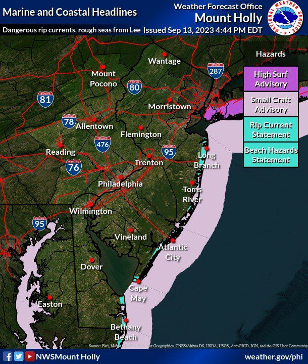
There is currently a Rip Current Warning and a High Surf Advisory in effect.
Swim only at guarded locations.
Bulk Trash Pick Up dates for Fall 2023 are September 18th and October 16th.
Items may be placed along the curb 72 hours prior to Pick Up.
NON-ACCEPTABLE ITEMS:
September 15, 2023
Lifeguards are on duty today at 83rd, 95th, 100th and 108th Streets.
There is a Rip Current Warning and a High Surf Advisory. Only enter the water at guarded locations.
September 15, 2023
From the National Weather Service
* WHERE…In Delaware, Delaware Beaches. In New Jersey, Eastern Monmouth, Atlantic Coastal Cape May, Coastal Atlantic and Coastal Ocean.
* WHEN…For the High Surf Advisory, until 6 PM EDT Saturday. For the High Rip Current Risk, through Saturday evening
* IMPACTS…Dangerous swimming and surfing conditions and localized beach erosion. Rip currents can sweep even the best swimmers away from shore into deeper water.
PRECAUTIONARY/PREPAREDNESS ACTIONS… Inexperienced swimmers should remain out of the water due to dangerous surf conditions. Swim near a lifeguard. If caught in a rip current, relax and float. Don`t swim against the current. If able, swim in a direction following the shoreline. If unable to escape, face the shore and call or wave for help.
HIGH RIP CURRENT RISK REMAINS IN EFFECT THROUGH SATURDAY EVENING
* WHAT…For the High Surf Advisory, large breaking waves of up to 8 feet in the surf zone. For the High Rip Current Risk, dangerous rip currents.
* WHERE…In Delaware, Delaware Beaches. In New Jersey, Eastern Monmouth, Atlantic Coastal Cape May, Coastal Atlantic and Coastal Ocean.
* WHEN…For the High Surf Advisory, until 6 PM EDT Saturday. For the High Rip Current Risk, through Saturday evening
* IMPACTS…Dangerous swimming and surfing conditions and localized beach erosion. Rip currents can sweep even the best swimmers away from shore into deeper water.
PRECAUTIONARY/PREPAREDNESS ACTIONS… Inexperienced swimmers should remain out of the water due to dangerous surf conditions. Swim near a lifeguard. If caught in a rip current, relax and float. Don`t swim against the current. If able, swim in a direction following the shoreline. If unable to escape, face the shore and call or wave for help.
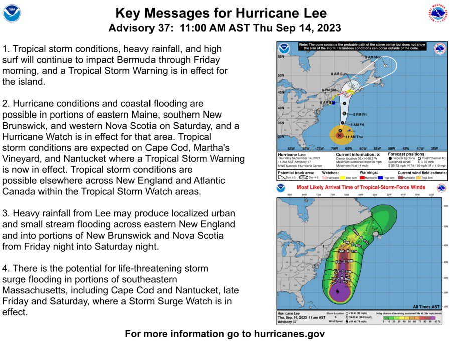
September 14, 2023 – A message from the Cape May County Emergency Management Communications Center
Here are the key messages for our region in regards to potential impacts from Lee at the end of this week.
1 – Dangerous surf and life-threatening rip currents are already affecting our region. These will only become more severe through the remainder of the week as the storm moves northward in the western Atlantic. They should start to subside by Sunday.
2 – The ocean waters are becoming increasingly hazardous for small craft as seas build, with waves possibly exceeding 10 feet by Friday.
3 – Minor coastal flooding and beach erosion will become a concern as the system makes its closest approach late Friday into Saturday.
4 – Winds over the ocean and adjacent near-shore regions may approach gale force (gusts to near 40 mph) late Friday into Saturday.
5 – At this time we a confident that no additional impacts will occur as the track of Lee is expected to remain well east.
We have also attached the current track forecast and wind speed probabilities as well as a graphic showing current local hazards. For the latest information on the track forecast, visit www.nhc.noaa.gov. For the latest rainfall amount forecast, visit https://www.wpc.ncep.noaa.gov/#page=qpf For the latest local forecast please visit www.weather.gov/phi
September 14, 2023
Borough of Stone Harbor
9508 Second Avenue
Stone Harbor, New Jersey 08247
(609) 368-5102
Borough Hall Office Hours 8:30am to 4:00pm
© Copyright | Borough of Stone Harbor | opens in a new windowJoyceMedia.com

