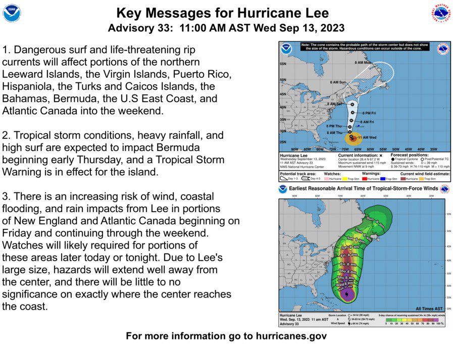
Night Closure of 96th Street Bridge September 18th through 21st, 8:00 pm – 6:00 am
September 14, 2023 – Message from the Office of the Cape May County Engineer
Notice of Night Closures for 96th Street Bridge (C.R. 657)
Borough of Stone Harbor and Township of Middle
The 96th Street Bridge along Stone Harbor Boulevard leading into the Borough of Stone Harbor will be undergoing repairs to the bascule span (movable span) during nighttime hours beginning on Monday, September 18th thru September 21st. Work will proceed Monday thru Thursday nights between 8:00pm to 6:00am. Due to the nature of the work, the bridge cannot remain open as work proceeds. Thru traffic wishing to access Stone Harbor via Stone Harbor Boulevard will be detoured during these work times with access to Stone Harbor directed to Avalon Boulevard. Local traffic wishing to access businesses and residences up to the west side of the bridge will be permitted to proceed along Stone Harbor Boulevard. The bridge will re-open at 6:00am each workday and remain opened until 8:00pm that night. There are no anticipated closures on Fridays thru Sundays during the construction phase.
Traffic heading north on the Garden State Parkway wishing to access Stone Harbor at exit 10 will be redirected to proceed north on the Parkway to exit 13 and proceed east on Avalon Boulevard (C.R. 601) to Ocean Drive (C.R. 619). Traffic will then be directed south along Ocean Drive to Stone Harbor. Traffic travelling south on the parkway will be directed to take exit 13 onto Avalon Boulevard as well. Traffic heading east on Court House South Dennis Road (C.R. 657) will be advised to either take Route 9 north to Avalon Boulevard or to take exit 10 north onto the Garden State Parkway to Avalon Boulevard. Stone Harbor traffic wishing to head west along Stone Harbor Boulevard will be directed north along Third Avenue /Ocean Drive (C.R. 619) and west along Avalon Boulevard (C.R. 601) to the Garden State Parkway.
The proposed work was prompted by the deflection/vibration of the top side bascule back plates under traffic loads and will address this condition along with other priority repairs deemed necessary by the latest NBIS bridge inspection. The proposed repairs will arrest deficiencies noted in the latest inspection report. The detour will be in place only during the periods of night work and normal traffic will resume Monday thru Thursday between 6:00am to 8:00pm.