jolson

About Jenny

This author has not yet filled in any details.
So far Jenny has created 528 blog entries.

August 15, 2023: Severe Storms Possible

August 15, 2023

A Message from the Cape May County Emergency Management Communications Center:

Here is the latest forecast for today:

Hazardous Weather: Isolated to scattered thunderstorms developing, with the potential for a few severe thunderstorms. Damaging winds will be the main threat with these storms.

Locations Affected: Thunderstorms are possible across the entire region, with the greatest risk for severe thunderstorms across the southern half of New Jersey, southeastern Pennsylvania, and all of Delmarva.

Timing: Roughly 2 PM through 8 PM from west to east.

Impacts: Damaging wind gusts from severe thunderstorms could knock down trees and powerlines.

Confidence: Moderate confidence on overall thunderstorm development. Moderate confidence on where and when the strongest thunderstorms move through, producing the greatest impacts.

August 15, 2023: Severe Storms Possible2023-08-17T10:05:49-04:00

Green Fair Postponed to August 14th Due to Potential Severe Weather

August 7, 2023

Due to the possibility of severe weather, Stone Harbor’s Go Green Committee has made the tough decision to cancel this evening’s Green Fair.

The event has been re-scheduled,  for Monday, August 14, 2023 from 6:00 pm to 8:00 pm.

Let’s keep our fingers crossed for clear skies and a fantastic time celebrating all things green!

Green Fair Postponed to August 14th Due to Potential Severe Weather2023-08-15T14:34:53-04:00

August 7, 2023: Risk For Severe Thunderstorms, Damaging Winds And Flooding

August 7, 2023

The Following is a message from the Cape May County Emergency Management Communications Center:
  • There is a risk for severe thunderstorms this afternoon into this evening producing damaging winds, with a couple tornadoes possible, and heavy downpours leading to some localized urban and small stream flooding.
  • Hazardous Weather: The primary severe weather hazard will be damaging winds, though a couple tornadoes are possible. There is some concern for hail, but it is much more uncertain if this will develop and it is not expected to be the primary threat. In addition, instances of heavy rainfall may lead to some flooding issues, mainly in the urban corridor.
  • Locations affected: The entire region is at risk for severe thunderstorms and localized flooding. The highest risk for damaging winds and any tornadoes is generally along and west of a Trenton to Philadelphia to Georgetown line. The highest risk for flooding is along the urban corridor. Refer to the attached graphics.
  • Timing: This afternoon through this evening. The greatest risk is between 4 PM to 10 PM
  • Impacts: Severe thunderstorms could produce damaging wind gusts bringing down trees and power lines resulting in power outages. Excessive rainfall rates could result in localized flash flooding, mainly limited to urban and poor drainage areas.
  • Confidence on occurrence: The risk for damaging winds occurring within our region is between 30 and 45%. The risk for flash flooding occurring within our region is 15 to 30%. The probability of a tornado occurring within our region is 2 to 5%. The probability of large hail occurring within our region is 5 to 10%.
August 7, 2023: Risk For Severe Thunderstorms, Damaging Winds And Flooding2023-08-09T12:33:24-04:00

August 2, 2023: Coastal Flood Advisory In Effect From 8 PM This Evening To 2 AM Thursday

August 2, 2023

From the National Weather Service:

A COASTAL FLOOD ADVISORY REMAINS IN EFFECT FROM 8 PM THIS EVENING TO 2 AM THURSDAY

  • WHAT: Up to one foot of inundation above ground level expected in low-lying areas near shorelines and tidal waterways.
  • WHERE: Atlantic, Cape May, Atlantic Coastal Cape May, Coastal Atlantic and Southeastern Burlington.
  • WHEN: From 8 PM this evening to 2 AM EDT Thursday.
  • IMPACTS…At this level, flooding begins on the most vulnerable roads in coastal and bayside communities, and along inland tidal waterways. Some partial or full road closures are possible.
  • ADDITIONAL DETAILS…Spotty minor flooding will be possible at the time of Thursday evening`s high tide.
  • PRECAUTIONARY/PREPAREDNESS ACTIONS… If travel is required, allow extra time as some roads may be closed. Do not drive around barricades or through water of unknown depth. Take the necessary actions to protect flood-prone property.
August 2, 2023: Coastal Flood Advisory In Effect From 8 PM This Evening To 2 AM Thursday2023-08-07T08:48:45-04:00

2023 Beach Nourishment Project Recap: Strengthening Stone Harbor’s Coastal Resilience

August 1, 2023

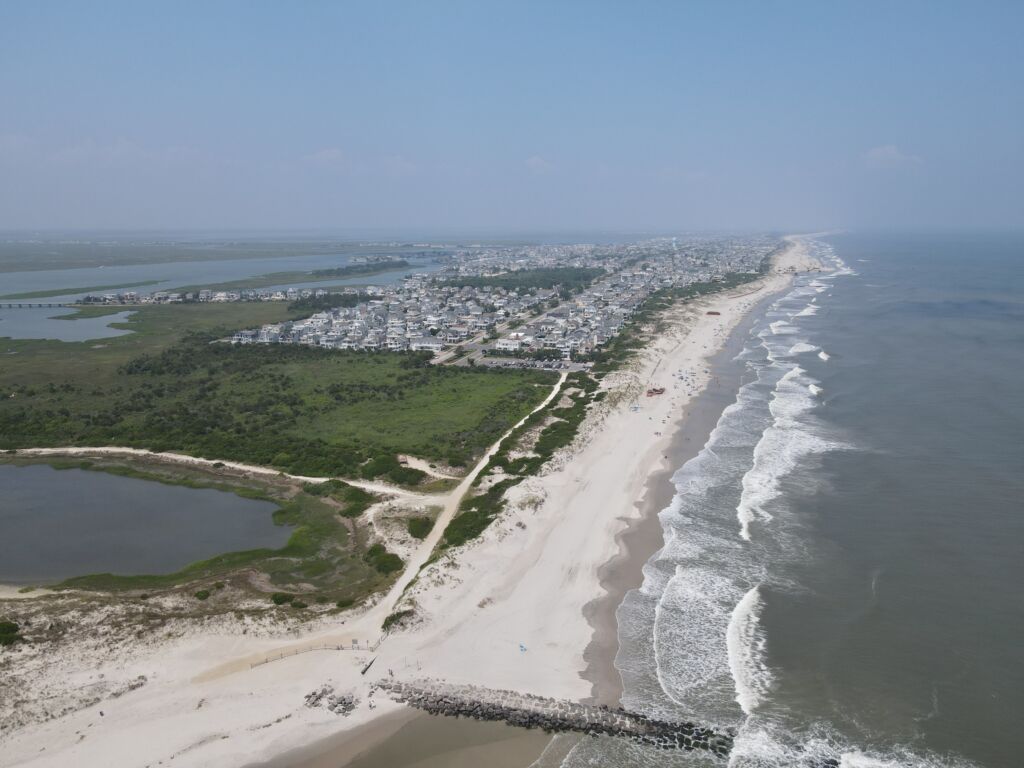
As of July 28, 2023, the dredging and beach fill portion of the 2023 Beach Nourishment Project was completed by Great Lakes Dredge and Dock Company. As a result, all beaches are accessible daily and the parking lot at 123rd Street is open. The much-needed beach fill now offers residents and visitors an enhanced coastal experience.

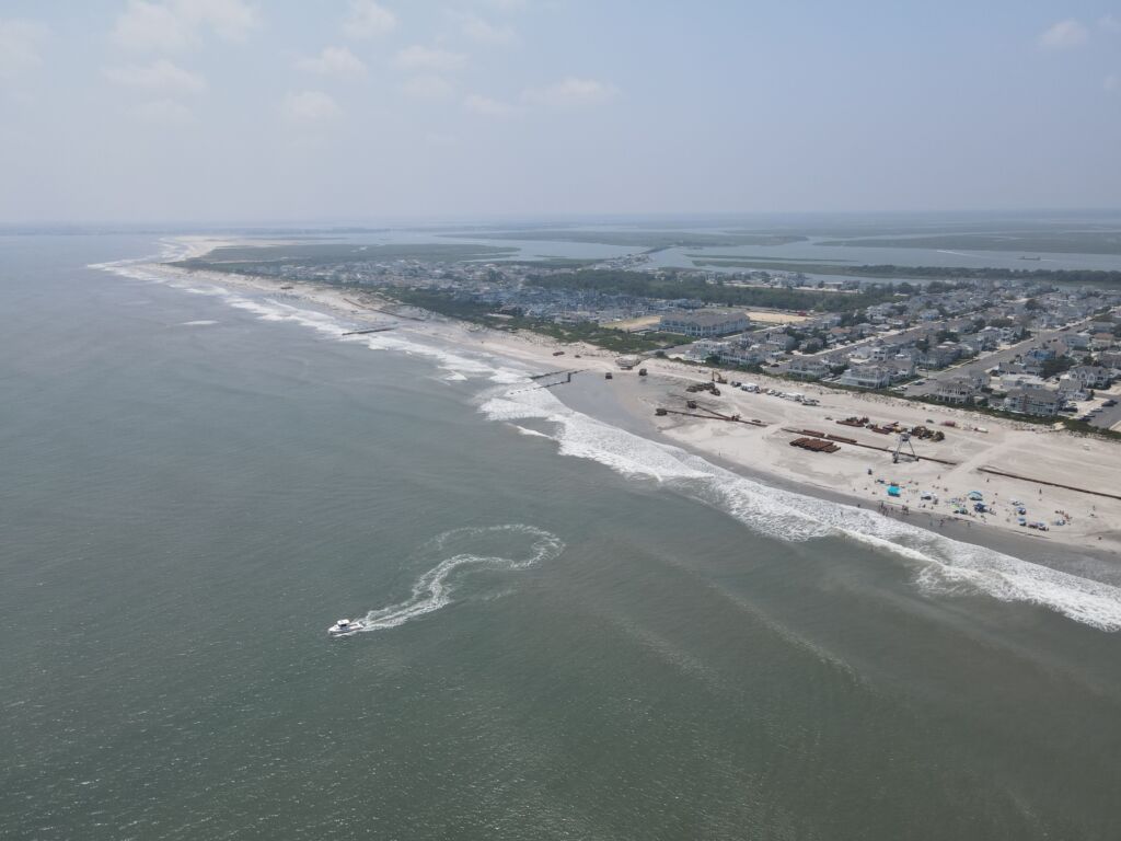
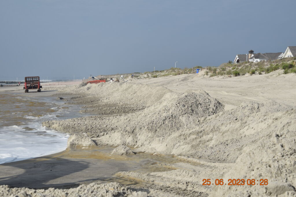
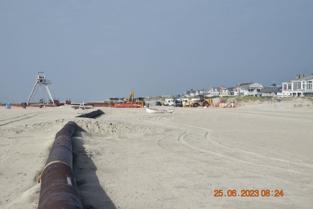
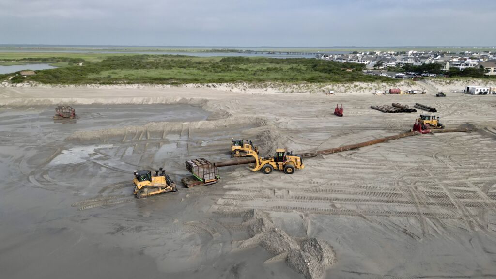
Project Overview: This joint effort between the U.S. Army Corps of Engineers, the New Jersey Department of Environmental Protection, and the Boroughs of Avalon and Stone Harbor was intended to strengthen the shoreline’s protection from coastal storm events. Great Lakes Dredge & Dock Company was awarded a $28.8 million contract to conduct the beach fill project in Avalon and Stone Harbor. It involved dredging sand from the Townsends Inlet borrow site, pumping it through a series of pipes onto the beaches, and grading it into an engineered dune and berm template.

As a result of the project, Stone Harbor received over 700,000 cubic yards of sand, resulting in wider beaches and, more importantly, a carefully engineered dune and berm structure to mitigate damage from storms.

Based on preconstruction surveys, the beach fill template was adjusted, and Stone Harbor received sand in three specific areas:

  • From 80th Street to 87th Street
  • From 89th Street to 115th Street, with slight narrowing at 96th and 97th Streets and a tapered approach at the start and finish points.
  • From 119th to 127th Street groin

Progress and Delays: The project started on April 17th at the north end of Avalon and progressed southward. Weather conditions and mechanical maintenance caused some delays, and the project eventually commenced in Stone Harbor on June 6th.  Dedication to the project remained steadfast while crews worked 24/7 through June and July.

On July 17, 2023, the dredging and beach fill project was successfully completed with an impressive 727,755 cubic yards of sand placed on Stone Harbor beaches. Subsequently, the demobilization operation cleared all beaches, crossovers, and parking lots, and concluded on July 28, 2023, restoring full accessibility. The contractor will return in the Fall for dune grass planting to finish the project completely.

The Borough of Stone Harbor is grateful to residents and visitors for their patience and support throughout this project. The completion of the beach nourishment project not only enhances our beaches but also reinforces our dunes, providing essential protection to our coastal community.

Below are video and photos of the project provided by the U.S. Army Corps of Engineers.

Click here for Beach Nourishment Video

Video Credit: Peter Smith, U.S. Army Corps of Engineers
Contact:
Jenny Olson
Director of Tourism and Public Information
Borough of Stone Harbor
609-368-5102 x 340
tourism@SHNJ.org

2023 Beach Nourishment Project Recap: Strengthening Stone Harbor’s Coastal Resilience2024-02-15T09:23:57-05:00

July 28, 2023, Beach Nourishment Demobilization Update: All Beaches Are Accessible & 123rd Street Parking Lot Is Partially Open

July 28, 2023

Beach Nourishment Demobilization Update

– The parking lot at 123rd Street is partially open on the south side of the lot.

– All beaches and crossovers are open.

– Completion of the project is expected sometime today.
July 28, 2023, Beach Nourishment Demobilization Update: All Beaches Are Accessible & 123rd Street Parking Lot Is Partially Open2023-08-02T15:50:31-04:00

July 27-29, 2023 Heat and Severe Weather Hazards

July 27, 2023 – From the National Weather Service

High heat and humidity will be in place through Saturday.

  •  Heat Advisories are in effect for today (Thursday July 27) as Heat Index values will range from 100° to 105°.
  • Scattered showers and thunderstorms will develop this afternoon through this evening (approximately 2pm to 10pm). Some storms may be severe with damaging wind gusts (60 to 70 mph) and heavy rain with localized flash flooding.
  • Excessive Heat Warnings are in effect for the urban corridor, including Philadelphia, and parts of NJ for Heat Index Values 105° to 109° on Friday, July 28. Heat Advisories in effect most elsewhere, including Delmarva and southern NJ, though criteria for Excessive Heat Warnings are higher there.
  • Afternoon and evening showers and thunderstorms possible Friday.
  • Heat Advisories may be needed Saturday for the urban corridor and parts of New Jersey. Late day and evening showers and thunderstorms are likely with damaging winds and localized flash flooding possible

Click Here for Complete NWS Briefing

July 27-29, 2023 Heat and Severe Weather Hazards2023-07-31T14:14:33-04:00

July 27, 2023, Beach Nourishment Demobilization Update: 123rd Street Lot Partially Open and All Beaches Accessible

July 27, 2023

July 27, 2023: Beach Nourishment Demobilization Update
– The parking lot at 123rd Street is partially open on the south side of the lot.
– All beaches and crossovers are open.
– The approximate date for completion of the project is sometime on Friday, July 28th, barring any weather or equipment maintenance delays.
July 27, 2023, Beach Nourishment Demobilization Update: 123rd Street Lot Partially Open and All Beaches Accessible2023-08-02T15:50:57-04:00
Go to Top