January 19, 2024, Borough Hall Closing At 2:00 PM Due To Winter Weather Conditions
January 19, 2024
Borough Hall will be closing at 2:00 p.m. today, January 19, 2024, due to the inclement weather.
January 19, 2024
Borough Hall will be closing at 2:00 p.m. today, January 19, 2024, due to the inclement weather.
January 19, 2024
A Message From the National Weather Service:
WINTER WEATHER ADVISORY REMAINS IN EFFECT UNTIL 10 PM EST THIS EVENING
* WHAT…Snow expected. Some rain may mix in this morning. Total snow accumulations of 2 to 4 inches. Winds gusting as high as 35 mph.
* WHERE…Atlantic Coastal Cape May, Coastal Atlantic and Coastal Ocean.
* WHEN…Until 10 PM EST this evening.
* IMPACTS…Plan on slippery road conditions. The hazardous conditions could impact the morning or evening commute.
* ADDITIONAL DETAILS…Temperatures will rapidly drop into the teens late Friday night. Any untreated roads will become icy and dangerous. Areas of blowing snow are possible over the weekend.
PRECAUTIONARY/PREPAREDNESS ACTIONS… Slow down and use caution while traveling.
January 18, 2024
Starting in February, construction will commence on the installation of a water main and services along the 200 block of 96th Street, spanning from Second Avenue to Third Avenue. The anticipated start date for the project is the first week of February, with an estimated duration of four weeks.
During the construction period, the roadway will be fully closed from Monday through Friday, specifically between the hours of 7:00 am and 3:30 pm. However, to minimize disruptions, the eastbound lane will be accessible during non-working hours. Additionally, the roadway is set to reopen for weekends, starting from Friday after the completion of work and continuing until Monday morning.
Sidewalks will remain open throughout the construction process.
We appreciate your understanding and patience as we undertake these essential improvements.
January 18, 2024
Please note that the public restrooms at the Water Tower Comfort Station are closed until further notice due to a heating issue.
We apologize for any inconvenience this may cause and thank you for your patience while we work to resolve the problem.
January 16, 2024
OFFICIAL NOTICE
Reconstruction of 96th Street – Second Avenue to Third Avenue
The Borough of Stone Harbor is proposing to repave the following streets, with construction scheduled to commence in April 2024.
1. 96th Street (Second Avenue to Third Avenue)
CLICK HERE FOR OFFICIAL NOTICE SENT TO AFFECTED PROPERTY OWNERS
January 12, 2024
Hazardous Weather Outlook from the National Weather Service:
HIGH WIND WARNING IN EFFECT FROM 8 PM THIS EVENING TO 5 AM SATURDAY
WIND ADVISORY IN EFFECT FROM 5 AM TO 5 PM SATURDAY
WHAT…For the High Wind Warning, southeast winds 30 to 40 mph with gusts of 50 to 60 mph expected. For the Wind Advisory, southwest winds 20 to 30 mph with gusts of 40 to 50 mph expected.
WHERE…In Delaware, Delaware Beaches. In New Jersey, Eastern Monmouth, Atlantic Coastal Cape May, Coastal Atlantic and Coastal Ocean.
WHEN…For the High Wind Warning, from 8 PM this evening to 5 AM EST Saturday. For the Wind Advisory, from 5 AM to 5 PM EST Saturday.
IMPACTS…Damaging winds will blow down trees and power lines. Widespread power outages are expected. Travel will be difficult, especially for high profile vehicles.
ADDITIONAL DETAILS…Southeast winds will increase this evening. Extremely saturated soils due to previous rainfall events may result in trees and power poles being more more susceptible to wind. Sporadic wind gusts up to 60 mph are possible along the immediate coastline. Winds will diminish somewhat and shift to the west Saturday morning with gusts up to 50 mph.
PRECAUTIONARY/PREPAREDNESS ACTIONS… People should avoid being outside around trees. Use caution if you must drive.
COASTAL FLOOD ADVISORY REMAINS IN EFFECT FROM 6 AM TO 2 PM SATURDAY
WHAT…One to two feet of inundation above ground level expected in low-lying areas near shorelines and tidal waterways.
WHERE…Atlantic, Cape May, Atlantic Coastal Cape May, Coastal Atlantic and Southeastern Burlington.
WHEN…From 6 AM to 2 PM EST Saturday.
IMPACTS…At this level, widespread roadway flooding occurs in coastal and bayside communities and along inland tidal waterways. Many roads become impassable. Some damage to vulnerable structures may begin to occur. At this level, flooding begins on the most vulnerable roads in coastal and bayside communities, and along inland tidal waterways. Some partial or full road closures are possible.
PRECAUTIONARY/PREPAREDNESS ACTIONS… If travel is required, allow extra time as some roads may be closed. Do not drive around barricades or through water of unknown depth. Take the necessary actions to protect flood-prone property.
opens in a new windowCLICK HERE FOR COMPLETE WEATHER BRIEFING
January 10, 2024
Please note that we are sold out of the 2024 Holiday Beach Tags. Regular Seasonal Tags for the summer of 2024 will be available sometime in the Spring.
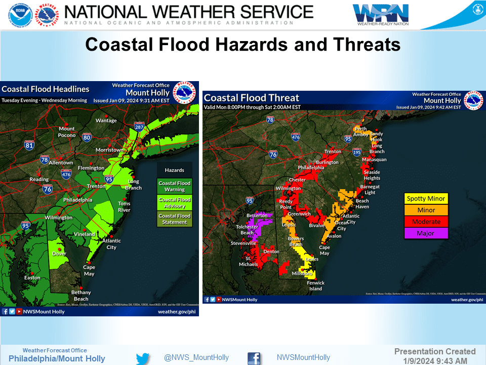
January 9, 2024, From the National Weather Service:
opens in a new windowCLICK HERE FOR COMPLETE WEATHER BRIEFING
COASTAL FLOOD ADVISORY REMAINS IN EFFECT FROM 5 PM THIS AFTERNOON TO 10 AM WEDNESDAY
WHAT…Up to one foot of inundation above ground level expected in low-lying areas near shorelines and tidal waterways.
WHERE…Atlantic, Cape May, Atlantic Coastal Cape May and Coastal Atlantic.
WHEN…From 5 PM this afternoon to 10 AM EST Wednesday.
IMPACTS…At this level, flooding begins on the most vulnerable roads in coastal and bayside communities, and along inland tidal waterways. Some partial or full road closures are possible.
ADDITIONAL DETAILS…The highest water levels are expected in the back bays.
PRECAUTIONARY/PREPAREDNESS ACTIONS… If travel is required, allow extra time as some roads may be closed. Do not drive around barricades or through water of unknown depth. Take the necessary actions to protect flood-prone property.
HIGH WIND WARNING REMAINS IN EFFECT FROM 6 PM THIS EVENING TO 4 AM WEDNESDAY
WHAT…Southeast to south winds 35 to 45 mph with gusts up to 65 mph expected.
WHERE…Portions of southern Delaware and central and southern New Jersey.
WHEN…From 6 PM this evening to 4 AM EST Wednesday.
IMPACTS…Damaging winds will blow down trees and power lines. Widespread power outages are expected. Travel will be difficult, especially for high profile vehicles.
ADDITIONAL DETAILS…Southeast winds will increase during today and become stronger later this afternoon. The damaging winds are expected to occur this evening, and these could be locally enhanced with a narrow line of intense showers later tonight.
PRECAUTIONARY/PREPAREDNESS ACTIONS… People should avoid being outside around trees. If possible, remain in the lower levels of your home during the windstorm, and avoid windows. Use caution if you must drive.
FLOOD WATCH REMAINS IN EFFECT FROM 1 PM EST THIS AFTERNOON THROUGH WEDNESDAY AFTERNOON
WHAT…Flooding caused by excessive rainfall continues to be possible.
WHERE…Portions of Delaware, including the following areas, Delaware Beaches, Inland Sussex, Kent and New Castle, northeast Maryland, including the following areas, Caroline, Kent MD, Queen Annes and Talbot, New Jersey, including the following areas, Atlantic, Atlantic Coastal Cape May, Camden, Cape May, Coastal Atlantic, Coastal Ocean, Cumberland, Eastern Monmouth, Gloucester, Mercer, Middlesex, Northwestern Burlington, Ocean, Salem, Southeastern Burlington and Western Monmouth, and southeast Pennsylvania, including the following areas, Delaware, Lower Bucks and Philadelphia.
WHEN…From 1 PM EST this afternoon through Wednesday afternoon. * IMPACTS…Excessive runoff may result in flooding of rivers, creeks, streams, and other low-lying and flood-prone locations.
ADDITIONAL DETAILS… – Rainfall of 1 to 3 inches possible later today and tonight, with the heaviest rain falling later this afternoon and this evening. The ground remains very saturated following multiple rounds of heavy rainfall over the last month. A period of higher hourly rainfall rates is possible tonight which would enhance the potential for flooding, particularly in the urban areas. Tidal inundation combined with runoff in coastal areas may significantly elevate the flood risk, especially if occurring during times of high tide. – opens in a new windowhttp://www.weather.gov/safety/flood
PRECAUTIONARY/PREPAREDNESS ACTIONS… You should monitor later forecasts and be alert for possible Flood Warnings. Those living in areas prone to flooding should be prepared to take action should flooding develop.
January 8, 2024
From the National Weather Service – Hazardous Weather Outlook for January 9-10, 2024:
FLOOD WATCH REMAINS IN EFFECT FROM TUESDAY AFTERNOON THROUGH WEDNESDAY AFTERNOON
* WHAT…Flooding caused by excessive rainfall continues to be possible.
* WHERE…Portions of Delaware, including the following areas, Delaware Beaches, Inland Sussex, Kent and New Castle, northeast Maryland, including the following areas, Caroline, Kent MD, Queen Annes and Talbot, New Jersey, including the following areas, Atlantic, Atlantic Coastal Cape May, Camden, Cape May, Coastal Atlantic, Coastal Ocean, Cumberland, Eastern Monmouth, Gloucester, Mercer, Middlesex, Northwestern Burlington, Ocean, Salem, Southeastern Burlington and Western Monmouth, and southeast Pennsylvania, including the following areas, Delaware, Lower Bucks and Philadelphia.
* WHEN…From Tuesday afternoon through Wednesday afternoon.
* IMPACTS…Excessive runoff may result in flooding of rivers, creeks, streams, and other low-lying and flood-prone locations.
* ADDITIONAL DETAILS… – Rainfall of 1 to 3 inches possible Tuesday through early Wednesday, with the heaviest rain falling Tuesday night. The ground remains very saturated following multiple rounds of heavy rainfall over the last month. A period of higher hourly rainfall rates is possible during Tuesday night which would enhance the potential for flooding, particularly in the urban areas.
Tidal inundation combined with runoff in coastal areas may significantly elevate the flood risk, especially if occurring during times of high tide. – http://www.weather.gov/safety/flood
PRECAUTIONARY/PREPAREDNESS ACTIONS… You should monitor later forecasts and be alert for possible Flood Warnings. Those living in areas prone to flooding should be prepared to take action should flooding develop.
HIGH WIND WATCH REMAINS IN EFFECT FROM TUESDAY EVENING THROUGH LATE TUESDAY NIGHT
* WHAT…Southeast to south winds 35 to 45 mph with gusts up to 65 mph possible.
* WHERE…In Delaware, Delaware Beaches. In New Jersey, Eastern Monmouth, Atlantic Coastal Cape May, Coastal Atlantic and Coastal Ocean.
* WHEN…From Tuesday evening through late Tuesday night.
* IMPACTS…Damaging winds could blow down trees and power lines. Widespread power outages are possible. Travel could be difficult, especially for high profile vehicles.
PRECAUTIONARY/PREPAREDNESS ACTIONS… Monitor the latest forecasts and warnings for updates on this situation. Fasten loose objects or shelter objects in a safe location prior to the onset of winds.
January 3, 2024
Congratulations to new Council Member, Tim Carney and incumbent Council Member, Robin Casper. Both were sworn in to their terms at the January 2, 2024 Borough Reorganization meeting by Borough Clerk, Emily Dillon.


Borough of Stone Harbor
9508 Second Avenue
Stone Harbor, New Jersey 08247
(609) 368-5102
Borough Hall Office Hours 8:30am to 4:00pm
© Copyright | Borough of Stone Harbor | opens in a new windowJoyceMedia.com

